Last modified: 2016-05-08 by alex garofolo
Keywords: irredentism | antofagasta | litoral | coat of arms: landscape | bandera cautiva |
Links: FOTW homepage |
search |
disclaimer and copyright |
write us |
mirrors

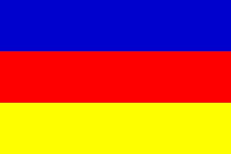
Litoral, the lost province and the only access to the sea.
Bolivia still claims this territory, which was
lost in the Pacific War (1879-1884) to Chile.
Jan-Patrik Fischer, 02 Jan 2002
This claim explains the existence of a Bolivian Navy
and a war ensign with 9+1 star.
Ivan Sache, 03 Jan 2002
This area is almost equivalent to nowadays Chilean Region of Antofagasta (or "II Región", provinces of Arica, Parinacota and Iquique); it was formerly a Bolivian province (Antofagasta or Atacama province). In February 1879 Bolivia tried to increase taxes on Chilean-owned nitrate mines in that province, and when Chilean companies refused, threatened to confiscate their properties. Bolivia felt self-assured because of a secret treaty of mutual defence signed in 1873 with Peru. When Bolivia blocked Chilean exports from its territory, the Chilean Navy took the port and city of Antofagasta and war broke out. The War of the Pacific (1879-1884) ended with Peru and Bolivia’s defeat, the Chilean Navy taking all the Peruvian and Bolivian ports and then the Army reaching as far as Lima.
By the Treaty of Ancón (Lima 1883), Peru lost the province of Tarapacá (about 330 km of coastline) and the provinces of Tacna and Arica (a further 80 km) were to be administered by Chile for a 10-year term, after which a plebiscite would decide on their destiny. Peru and Chile never agreed the terms of such plebiscite, and finally the 1929 Treaty of Lima returned Tacna to Peru and gave Arica definitely to Chile.
By the 1884 Truce, Bolivia lost its only coastal province of Antofagasta, about 510 km of coastline and (most important) all of the nitrate deposits of the Atacama desert. Chile agreed to build a railway from La Paz (Bolivia) to Arica and to grant freedom of transit for Bolivian commerce.
Santiago Dotor, 29 Oct 1999 and 05 Feb 1999
The area around Gatico, formerly Cobija (North Antofagasta region in
Chile) used to be Bolivian; according to Stielers Handatlas (1877) from
the Rio Loa (present northern boundary of Antofagasta to the 24th degree
SL, just south of Antofagasta city. The frontier there was formed by
that latitudinal line. On Martin’s Atlas of the 19th cenrury (1851,
reprinted 1989) the southern boundary starts at the little port of
Huesco del Prado and runs slightly southward.
Jarig Bakker, 29 Oct 1999
The national coat of arms has 10 stars now.
The 10th star represent Litoral department.
Jan-Patrik Fischer, 02 Jan 2002
The flag is called bandera cautiva and was
adopted as the naval ensign
adopted for Bolivia in 1841
at the time of President General José Ballivian.
[m2nXX]
Jaume Ollé, 02 Nov 1996
On 21 March 2004, the Bolivian President Carlos Mesa hoisted in La Paz the flag of the Littoral department, which was lost after the Pacific War (no pun intended!), 1879-1883. The Head of the Armed Forces and Police stood beside the President.
The hoisting of the flag was the preliminary to the celebration of the Sea Day (Día del Mar), celebrated in Bolivia every 23 March. The flag was hoisted on the Arms’ Square in La Paz, as well as on the Executive and Legislative Palace, along with the flags of the other nine Bolivian departments.
A column of the Colorados regiment, which fought during the Pacific War, beat the drum during the ceremony.
Ivan Sache, 19 May 2004
.gif)
In two of the pictures of this flag that I have there
is an off-centred shield, but in the
original naval
ensign I think the shield had the sun rising behind
Potosí Hill, between two wreaths of laurel
and olive.
Jaume Ollé, 02 Nov 1996
a.gif)
Anything below this line was not added by the editor of this page.