 image by Dirk Schönberger,
31 December 2011
Source: at http://www.pmaugustopestana.com.br/texto-simbolos.php

Last modified: 2012-02-11 by ian macdonald
Keywords: rio grande do sul | augusto pestana |
Links: FOTW homepage |
search |
disclaimer and copyright |
write us |
mirrors
 image by Dirk Schönberger,
31 December 2011
Source:
at
http://www.pmaugustopestana.com.br/texto-simbolos.php
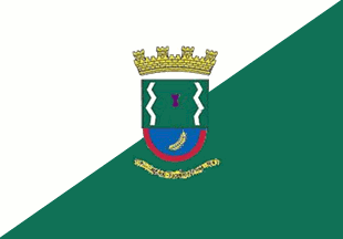
Diagonally divided white over green per bend sinister with the municipal arms in the centre.
Official website at
http://www.pmaugustopestana.com.br
Dirk Schönberger,
31 December 2011
The municipality of Augusto Pestana (7,273 inhabitants; 331.44 sq. km) is
located in northwestern Rio Grande do Sul, 425 km of Porto Alegre.
The
municipality is named for engineer Augusto Pestana, head of the Ijuí Colony Land
Commission, who called the place Serra Cadeada. Here, "cadeada" (lit. "locked")
recalls the huge locked gate of the estate owned by Dr. Raimundo Silva's widow.
The municipality of Augusto Pestana was formed on 17 September 1965 by State Law
No. 5,053 and inaugurated on 14 May 1966; its territory was taken from the
municipalities of Ijuí, Cruz Alta and Santo Ângelo.
The flag of
Augusto Pestana is prescribed by Municipal Law No. 01, signed
on 31 January 1977 by Mayor Ari Hintz. It is made of two triangles, the upper
white and the lower right, with the municipal coat of arms in the middle.
The coat of arms of Augusto Pestana has a green field charged with two
white sinuous lines representing the two natural divisions of the
municipality, in the middle a red key hole. The semi-circular base of the
shield is blue with a red border, charged in the middle with a yellow wheat
ear with a green leaf. The shield is surmounted by a yellow four-towered
mural crown recalling the town status of Augusto Pestana. Below the shield is
a yellow scroll charged with "1901, Cadeado – 1966 Augusto Pestana".
The flag is hoisted in the Mayor's office, together with the flags of Brazil
and of Rio Grande do Sul.
http://www.pmaugustopestana.com.br/imagens/gabineteG.jpg - Photo
Ivan Sache, 6 January 2012