 image located by Ivan Sache,
13
July 2020
Last modified: 2020-07-14 by ian macdonald
Keywords: rio grande do sul | cambará do sul |
Links: FOTW homepage |
search |
disclaimer and copyright |
write us |
mirrors
 image located by Ivan Sache,
13
July 2020
The municipality of Cambará do Sul (6,545 inhabitants; 12,126 ha) is located
200 km north-east of Porto Alegre. The municipality is composed of the districts
of Cambará do Sul (seat), Osvaldo Kroeff and Bom Retiro.
Cambará do Sul is
among the Brazilian places with the coldest winter. A temperature of -32.1C was
recorded on 31 July 1978.
Cambará do Sul emerged as a donation made by
Úrsula Maria da Conceição, member of a famous local family, who offered 20 ha on
17 April 1864 to erect a chapel dedicated to St. Joseph.
São José do Campo
Bom was elevated on 23 December 1902 to the 4th district of the newly
established municipality of São Francisco de Paula. At the end of the 1930s, the
district was granted the rank of "vila" and its name, already used by another
municipality, was changed to Vila Cambará, a name based on common lantana ("cambará",
_Lantana camara_ L.) growing profusely in the area.
The municipality of
Cambará do Sul was established on 23 December 1963 and inaugurated on 1965.
http://cambaradosul.rs.gov.br/
Municipal website
Ivan Sache, 13 July 2020
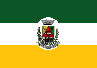
The flag of Cambará do Sul is horizontally divided green-white-golden yellow
with the municipal coat of arms inscribed in a white ellipse.
The dark
green stripe represents the plant resources.
The white stripe represents
peace and harmony required for common development, progress and common goods.
The yellow stripe represents the resources of the soil and the work of people.
The coat of arms features:
- a honeycomb and bees representing
bee-keeping as a source of income.
- a black bovine's head representing the
oldest source of income in the municipality through extensive cattle-breeding.
- a red equilateral triangle used by the Catholic church and other Christian
religions to symbolize the presence of God via the Holy Trinity.
- a black
stylized cogwheel representing industry.
- a paper sheet symbolizing the main
municipal industry, paper production.
- Itaimbézinho [canyon] and the
Secret's Stone. The two tourism hotspots of the municipality are represented to
symbolize tourism as a fundamental source of income.
- Pine branches to
symbolize the feedstock of the local transformation industry (timber, furniture
etc.).
- Apple branch to symbolize arboriculture as a main source of income,
Cambará do Sul being Rio Grande do Sul's 5th biggest apple producer.
- Towers
symbolizing the three powers, Legislative, Executive an Judiciary.
- Shield's
colors representing those of the flag of Rio Grande do Sul, green, yellow and
red.
http://cambaradosul.rs.gov.br/secao.php?pagina=3
Municipal website
Image from the municipal website
http://cambaradosul.rs.gov.br/secao.php?pagina=3
Ivan Sache, 13 July 2020