 image
by Olivier Touzeau, 29 Dec 2016
Last modified: 2022-10-22 by bruce berry
Keywords: ogooue lolo | gabon |
Links: FOTW homepage |
search |
disclaimer and copyright |
write us |
mirrors
 image
by Olivier Touzeau, 29 Dec 2016
Ogooué-Lolo Province covers an area of 25,380 km² and has 66,000 inhabitants
(2013). The provincial capital is Koulamoutou. The province is named after
two rivers - the Ogooué and its tributary, the Lolo River.
Ogooué-Lolo is divided into 4 departments:
- Lolo-Bouenguidi (Koulamoutou)
- Lombo-Bouenguidi (Pana)
- Mouloundou (Lastoursville)
- Offoué-Onoye (Iboundji)
Olivier Touzeau, 29 Dec 2016
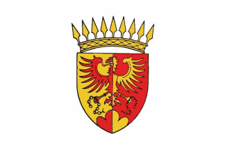
The provincial flag, as seen during the 2016 inauguration of the President of Gabon, is white with the provincial coat-of-arms occupying 4/5 of the height in the centre.
According to Heraldry of
the World, the eagle and the mountain symbolise that Gabon's highest
mountains lie in the region. Mont Iboundji was said to be the highest point of
the country, with an altitude of 972 metres, but in fact Mont Bengoué in
Ogooué-Ivindo Province is the most elevated peak in Gabon at 1,070 metres.
The partition stands for the two grand sectors (before 1975) of Koula-Mouyon and
Lastoursville. The broken chains recall the liberation of the slaves by the
French explorer Savorganan de Brazza.
Olivier Touzeau, 29 Dec 2016