 Shipmate Flagchart : http://www.flagchart.net
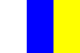
adopted 29 July 1954

Last modified: 2018-12-15 by rob raeside
Keywords: doetinchem |
Links: FOTW homepage |
search |
disclaimer and copyright |
write us |
mirrors
 Shipmate Flagchart : http://www.flagchart.net
adopted 29 July 1954
At this
webpage is an explanation about Doetinchem's flag:
Nothing is known about the flag(s) used in ancient times in Doetinchem.
Only in 1938 the flag of Doetinchem is being discussed, in connection with
the 40-years jubilee of Queen Wilhelmina. This flag was about the same
as the one of the province of Gelderland: two horizontal stripes yellow
and blue. In the canton was the municipal Coat of Arms. Yellow and blue were probably
chosen because azure-blue and gold are the main color of the municipal
Coat of Arms.
The municipality was advised to use vertical stripes, because some other
municipalities, as well as the polderboard did already use horizontally
striped flags.
In 1954 the municipal council instituted the three-striped version
of white - blue - yellow, in equally wide vertical stripes.
Jarig Bakker, 3 Jun 2003
![[Doetinchem's 1938 flag]](../images/n/nl-ge_dc.gif) by Jarig Bakker, 3 Jun 2003
by Jarig Bakker, 3 Jun 2003
![[Doetinchem Coat of Arms]](../images/n/nl-ge)dc.jpg) image from the Doetinchem municipal
website.
image from the Doetinchem municipal
website.
Granted 15 Dec 1920.