The flag reflects Muslim conquest of Sudan, which had already been under way when the "Book of All Kingdoms" was completed, although still far from the end.
Tomislav Todorovic, 04 Sept 2016
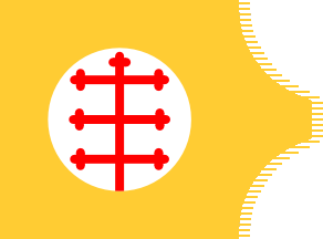
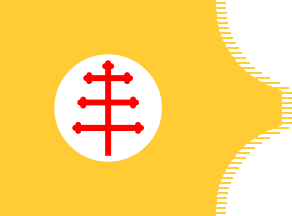
The other two flags represent the Christian states in Nubia, which were still very powerful at the time when the "Book of All Kingdoms" was completed, although the geographic information presented in the map is somewhat confused. The design of these flags resembles somewhat the flag of Dongola from the "Book of All Kingdoms". The city of Dongola is shown in the map, but with no flag. The flag is placed much farther to the south from its actual location, near the supposed Blue Nile, far upstream from its confluence with the White Nile. Its actual location was on the Nile, further downstream from the confluence, and the present-day city is placed even further downstream. The first of these flags was hoisted over a city named Sohan, placed at the confluence of the Niles, where the present-day city of Khartoum is located. The other flag was hoisted over a city named Dobaha, placed to the south-west from Sohan and to the south from the supposed White Nile. Since another Christian city named Sobaha is shown (without the flag) not far from Dobaha in the west, it is possible that all of these names, resembling each other, are somehow derived from the name of Soba, the historical capital of Christian kingdom of Alodia, which was placed on the Blue Nile, not far from the present-day Khartoum.
Tomislav Todorovic, 04 Sept 2016
Sohan
 image by Tomislav Todorovic, 04 Sept 2016
The flag of Sohan has an engrailed fly and displays a large white
disc, charged with a red eight-armed cross, on a golden field. All six
side arms of the cross have approximately the same length, the top arm
is very short, and the bottom arm is issuing from the disc edge. The
endings of the top and side arms are not all the same: some look like botonny and others like formy, but such asymmetrical cross shapes,
while their blazons are technically feasible, seem not to have ever
been used. When zoomed in to the maximum, the map photo seems to
reveal that there are more arms bottony than formy, so the cross is
shown here with all arms formy.
Tomislav Todorovic, 04 Sept 2016
Dobaha
 image by Tomislav Todorovic, 04 Sept 2016
The flag of Dobaha is very similar to that of
Sohan, but the disc is
smaller and the bottom arm of the cross does not reach the disc edge.
Also, the side arms' length is increasing from the top to the bottom,
resulting in a shape very similar to the papal cross. For all these
reasons, the flag is presented here separately.
Tomislav Todorovic, 04 Sept 2016

 image by Tomislav Todorovic, 04 Sept 2016