
This page is part of © FOTW Flags Of The World website
South African local flags in c. 1576
Last modified: 2022-10-22 by bruce berry
Keywords: south africa | portulano | dourado (fernão vaz) |
Links: FOTW homepage |
search |
disclaimer and copyright |
write us |
mirrors
See also:
Introduction
I have a small reproduction of an old map made by Fernão
Vaz Dourado in 1576. This map reproduces the southeastern coastal areas
of Africa, from southern Namibia to the easternmost tip of Somalia. It
contains nine reproductions of flags over those “city drawings” so common
in the maps of that time. I GIFfed the flags to the best of my eye resolution
(the reproduction is small and some details are not obvious). These are:
Are these flags really the flags used by those places at the time? Or,
rephrasing the question: are these maps reliable in what concerns flag-info
(they are not in what concerns geo-info, that’s for sure!...)
Jorge Candeias, 04 Apr 1998
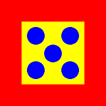
Eastern Transvaal
 image
by Jorge Candeias, 04 Apr 1998
image
by Jorge Candeias, 04 Apr 1998
Placed over the eastern Transvaal. The
flag is like tz-1576s, except that is lighter and the colours are reversed.
Jorge Candeias, 04 Apr 1998
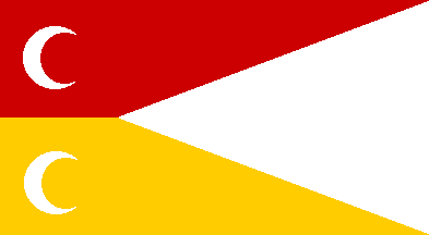
SE South Africa
 image
by Jorge Candeias, 04 Apr 1998
image
by Jorge Candeias, 04 Apr 1998
Placed in SE South Africa or Swaziland.
The flag is very similar to tz-1576n, except that this one is really maroon.
Jorge Candeias, 04 Apr 1998
Orange river mouth
 image
by Jorge Candeias, 04 Apr 1998
image
by Jorge Candeias, 04 Apr 1998
Placed to the south of the Orange
river's mouth. The flag is identical to mz-1576n.
Jorge Candeias, 04 Apr 1998